Africa has the most countries of any continent with a total of 54.
Rather than following natural terrains or historical boundaries, many of its borders are strikingly straight in some areas and jagged in others, cutting through mountains, rivers and even communities.
Most of these artificial borders trace back to the 1884-1885 Berlin Conference, a meeting that concluded 140 years ago this week in which European powers carved up the continent among themselves with no African nations invited or represented.
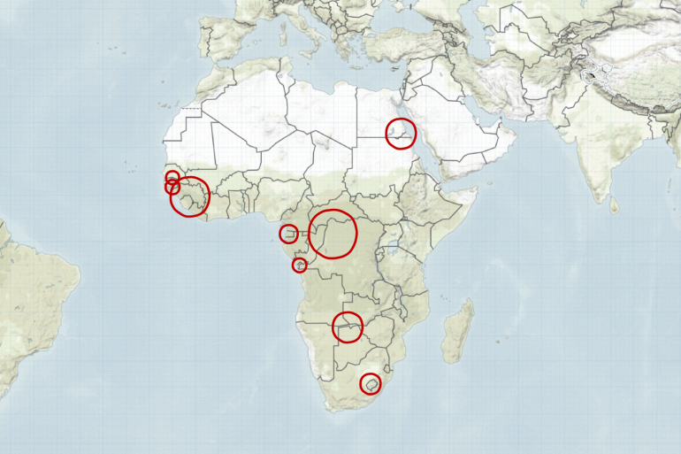
In this visual explainer, Al Jazeera delves into the stories behind some of the continent’s most unusual borders.
Egypt or Sudan – why does no one want Bir Tawil?
Starting in northeastern Africa is a 2,000sq-km (795sq-mile) uninhabited, arid piece of land that neither Egypt nor Sudan wants to claim as their own.
In 1899, Britain drew a straight-line border along the 22nd parallel, a line of latitude 22 degrees north of the equator, separating Egypt and Sudan, two territories under British control.
However, in 1902, Britain reassigned the coastal and resource-rich Hala’ib Triangle to Sudan and Bir Tawil to Egypt for geopolitical and administrative reasons.
Decades later, after both countries gained independence, Egypt insisted that the true border should follow the 1899 agreement while Sudan argued that it should follow the 1902 demarcation. Bir Tawil remains unclaimed by either country because claiming it would require forfeiting claims to the Hala’ib Triangle.
Egypt has controlled the Hala’ib Triangle since 2000, but the dispute remains unresolved.

Why is The Gambia so narrow?
As you travel along Africa’s western coast, you’ll see a narrow strip of land wrapped around the Gambia River and almost entirely surrounded by Senegal. This is The Gambia, the smallest country in mainland Africa and home to about three million people.
First explored by the Portuguese in the 15th century, The Gambia later became a major hub in the transatlantic slave trade. It remained a British colony from 1821 until gaining independence in 1965. Due to its proximity to then-French Senegal, its territorial boundaries were a point of contention between British and French authorities.
In 1889, Britain and France formally established The Gambia’s borders, agreeing that British control would extend about 16km (10 miles) on either side of the river, reaching its furthest navigable point at Yarbutenda.
A popular legend suggests that British forces fired cannonballs from their ships to determine the country’s width, ensuring control over vital trade routes. While no evidence supports this claim, historical records indicate that an Anglo-French commission in 1891 tried to refine the borders but faced resistance from local rulers whose lands were being arbitrarily divided.
Ultimately, The Gambia’s borders were shaped by colonial interests and British military power, leaving it as a long, narrow enclave within Senegal.

Why is Cabinda part of Angola?
Heading south along the continent’s western coast, you’ll come across a small section of Angola separated from the rest of the country. This is Cabinda, Angola’s northern province, cut off from the rest of the country by a narrow strip of the Democratic Republic of the Congo.
Cabinda became part of Angola due to historical decisions made during Portuguese colonial rule.
During the 1884-1885 Berlin Conference, Cabinda was formally recognised as a Portuguese possession, separate from Angola, although both were under Portuguese rule. Over time, Portugal administratively merged Cabinda with Angola, but the region remained geographically and culturally distinct.
When Portugal withdrew from its African colonies in 1975, the Alvor Agreement, signed with Angola’s main liberation groups, excluded Cabindan representation. and Cabinda was merged with Angola, primarily for its valuable offshore oil reserves.
This sparked resistance from the Cabindan independence movement, particularly the Front for the Liberation of the Enclave of Cabinda, which has continued to call for Cabinda’s independence from Angola.

Why does Namibia have a little panhandle?
As you move into Southern Africa, you may notice a narrow panhandle jutting out from Namibia. This is the Caprivi Strip.
Until the early 20th century, Germany controlled German South West Africa (now Namibia) and German East Africa (now Tanzania, Rwanda and Burundi) while Britain controlled the surrounding territories, including modern-day Botswana and Zambia.
Germany was looking for a direct trade route to link its territories and wanted access to the Zambezi River. The plan was to navigate the river to the Indian Ocean, providing a shortcut to Tanzania.
In 1890, Germany and Britain signed a treaty in which Germany gave up claims to Zanzibar in exchange for Heligoland, an island in the North Sea, and control of the Caprivi Strip, which met the Zambezi River.
However, Germany’s transport plan failed. It is believed that no one told the Germans about Victoria Falls – one of the world’s largest waterfalls with a 108-metre (354ft) drop, about 65km (40 miles) east of the strip, making it useless for transport.

Nestled in the mountains of Southern Africa lies a small landlocked country entirely surrounded by South Africa called Lesotho.
In the 19th century, the Basotho people, led by King Moshoeshoe I, established their stronghold in the highlands, using the mountains as a natural defence against invaders like the Zulu and Boer settlers (Dutch farmers).
To resist Boer expansion, Moshoeshoe sought British protection in 1868, making Basutoland a British protectorate.
Attempts to place it under Colonial Cape rule failed due to Basotho resistance, and in 1884, Britain declared it a crown colony.
When the Union of South Africa formed in 1910, Basutoland remained under British rule, avoiding South Africa’s apartheid policies, and later gained independence in 1966 as Lesotho.

Why are three African countries named Guinea?
Four countries around the world have “Guinea” in their names, three of which are along the West African coast.
They are:
- Guinea, formerly known as French Guinea, gained independence in 1958 and kept the name Guinea.
- Guinea-Bissau, formerly known as Portuguese Guinea, gained independence in 1974 and added “Bissau” to its name to differentiate itself from neighbouring Guinea.
- Equatorial Guinea, formerly known as Spanish Guinea, gained independence in 1968 and added Equatorial to its name because it is near the equator.
On the other side of the world lies Papua New Guinea, named by a Spanish explorer who named it after Guinea in West Africa, believing the locals resembled its inhabitants.
The name Guinea is believed to have been derived from the Portuguese word Guine, which referred to the region along the West African coast. When European colonisers divided this region, each called their territory Guinea.
Fun fact: The British guinea coin, first minted in 1663, was named after the region of Guinea in West Africa because the gold used to produce it came from there.

Why are there two Congos?
On opposite sides of the Congo River lie two countries named after it: the Democratic Republic of the Congo and the Republic of the Congo.
Colonial powers Belgium and France established separate colonies along the river, naming each after it. The name Congo comes from the Kingdom of Kongo, a powerful kingdom that once flourished along the river.


